PROBLEM
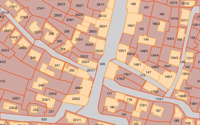
Washington County, Neb. was seeking to modernize and implement a geographic information system (GIS) solution to provide better inter-government collaboration. In addition, converting and creating parcels was needed to provide accurate and updated layers for the new system.
SOLUTION
ADC converted the County’s parcels from AutoCAD files, incorporated parcels from the City of Blair, and the remainder of the County’s parcels were scanned and digitized. ADC also linked the attributed parcel layer to the County Assessor’s TerraScan database.
RESULTS
Further, ADC developed and integrated basic GIS layers into a preliminary GIS system for use throughout the County’s departments. These basic layers were procured from outside sources or created by ADC, and include road centerlines, hydrology, registered wells, fire districts, school districts and SIDs.